Tools \ Rastertools
A command line for running various calculation tools.
Source codeMaturity : Prototype | Categories : Features Extraction, Processing Chains (pipelines) | License : | Producer : CNES
Overview
The project provides a command lined named rastertools allowing to run various calculation tools :
- computing radiometric indices on satellite images
- computing the speed of evolution of image radiometry between two dates
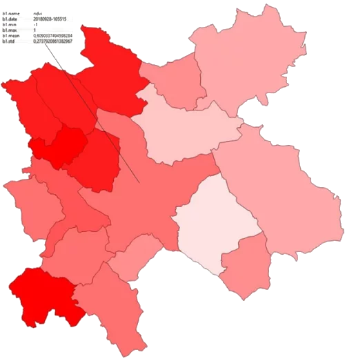
- computing zonal statistics of the bands of a raster, i.e. statistics such as min, max, average, etc. on sub-areas (defined by a vector file) of the area of interest.
- cropping a raster image into tiles following the geometries defined in a vector file
- applying a convolutional filter (median, local sum, local mean, adaptive gaussian)
- computing the Sky View Factor and shading for a DEM (Digital Elevation Model) raster.
The rastertools project also aims to make the handling of the following image products transparent :
- Sentinel-2 L1C PEPS
- Sentinel-2 L2A PEPS
- Sentinel-2 L2A THEIA
- Sentinel-2 L3A THEIA
- SPOT 6/7 Ortho de GEOSUD
Usage example
The tool is used by calling the rastertools command which activates the different tools and filters available. All details can be found in the documentation.
Tutorials
There is no available tutorial for this tool.