Getting started \ Processing chains, pipelines, applications
![]() At CNES we develop several end to end tools that can be launched using Command Line Interface (CLI) or other APIs like Python.
These processing chains are used in our production centers (and by others) to provide high level products accessible
to users and scientists.
At CNES we develop several end to end tools that can be launched using Command Line Interface (CLI) or other APIs like Python.
These processing chains are used in our production centers (and by others) to provide high level products accessible
to users and scientists.
This page aims at providing an overview of the main tools that are developed by CNES or widely used in our projects. This is not an exhaustive list of the tools we develop or use.
Generic tooling
The following tools are often used by others in the following paragraphs to build complex processing chains. They can be used on their own, but they are more considered as generic frameworks enabling the developement of complete pipelines.
- OrfeoToolBox offers a lot of implemented algorithms on top of GDAL and ITK with many features like stream processing.
- Xarray and more generaly all the Pangeo ecosystem around, with rioXarray, odc.geo allows writing data processing pipelines on scientific datasets.
- OpenEO provides API and platform to build pipelines reproducible on infrastructures providing this backend.
Satellite time series and optical imagery
CNES and assiociated labs like CESBIO have an expertise in raster imagery processing. Several tools have been developed, and are used in CNES and European ground segments:
- MAJA: Level-2A processor used for atmospheric correction and cloud-detection.
- Rastertools: a command line and Python API for running various calculation tools on rasters.
- SLURP: processes a VHR image and computes a simple land-use mask (water, low/high vegetation, bare ground, buildings).
- Iota2: a land-use map production line for large areas based on time series of Sentinel or Landsat images.
SAR processing
We have several services at CNES and associated labs dedicated to SAR and altimetry processing, which build the following tools (and plenty others):
- S1Tiling: on demand Ortho-rectification of Sentinel-1 data on Sentinel-2 grid.
- Tropisco: following tropical deforestation using SAR imagery.
- DiapOTB: Orfeo Toolbox remote module that contains all necessary steps and allows to launch a complete DInSAR chain.
3D and DEM tool set
CNES has a team dedicated to developing 3D products and algorithms based on Very High resolution imagery, like Pleiades and next generations satellites. There are also more low level tools to work with DEM or point clouds. Some of the most used processing chains or end to end tools are the following:
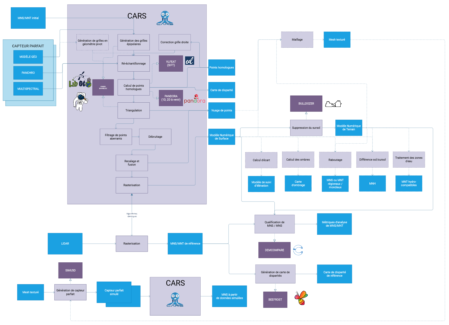
- CARS: an open source 3D tool dedicated to produce Digital Surface Models from satellite imaging by photogrammetry.
- Pandora2D: a coregistration tool that provide disparity maps for images pairs.
- DEMcompare: a python software that aims at comparing two DEMs together.
- CloudCompare: lets you open and visualize 3D data including point clouds and meshes.
Hydrology
CNES develops processing chains and hosts a processing center for producing Hydrology variables like water masks or snow cover area in moutains:
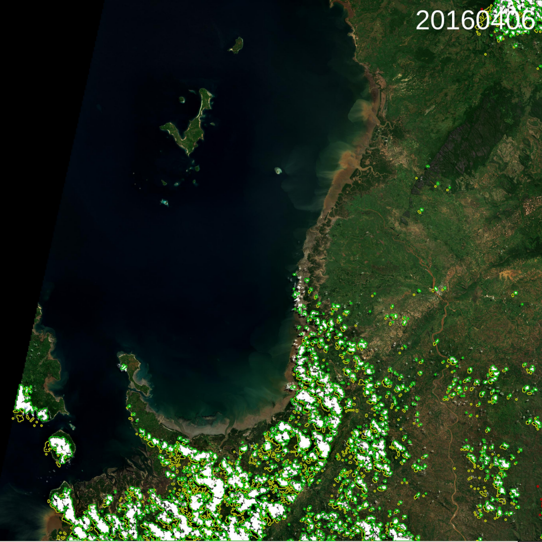
- Let it Snow: snow detection algorithm on various satellite products and temporal synthesis on time series of snow products.
- SurfWater: Water masks processing and other higher level products.
- GRS: Glint Removal for Sentinel-2-like sensors, used for Water quality.
Others
Of course, there are plenty other subjects of interest at CNES like Atmospheric studies or image quality. With for example the following tools: